


|
THE FOLLOWING MAPS ARE NOT TO BE USED FOR NAVIGATIONAL PURPOSES.
 View the slideshow for more sequential photos of this hike.
|
Length: 15 miles including Rainy Lake loop
Elevation Change: 4400' gain
Season: Midsummer thru Fall
Difficulty: Very Difficult due to steepness and
length of hike
Permit: NW Forest Pass Required
Features: 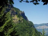
Now here is a hike that will get your old heart a pumpin. Yep, a real
doozy. This is an excellent hike for endurance. You begin the hike
at the Wyeth trailhead, which is located at the south end of the
Wyeth campground just off I85 and exit 51. Trail takes your around
the south end of the campground then crosses the stream next to
it. There wasn't a bridge there when I crossed, so I assume there
still isn't.
After you cross the creek, the trail still wanders a bit through a dense
forested area. It slowly gets steeper and steeper. Then comes a sharp
swithback and the trail climbs about 3500' in the next three miles. There
are a small number of viewpoints along the trail, but for the most part
this hike is in the woods. At the four mile point, you come to a junction
where you bear to the right and climb another 600' to the top of Green Point
Ridge.
 In about another mile or so the trail encounters the Gordon Creek trail from Nick Eaton Ridge and
Herman Creek. Then in about a quarter of a mile you will come to a small
area where you can leave the trail and walk over to an opening in the forest
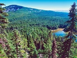
and view across to Mt. Defiance and below to North Lake. In another mile
and a half you will encounter another trail that is part of the Gordon Creek
Trail system. Bear left at this point and take Trail #423 toward North Lake.
In about another mile or so the trail encounters the Gordon Creek trail from Nick Eaton Ridge and
Herman Creek. Then in about a quarter of a mile you will come to a small
area where you can leave the trail and walk over to an opening in the forest
and view across to Mt. Defiance and below to North Lake. In another mile
and a half you will encounter another trail that is part of the Gordon Creek
Trail system. Bear left at this point and take Trail #423 toward North Lake.
 The southern exposure of Green Point Ridge does offer some excellent
views of Mt Hood, Rainy Lake, and the surrounding terrain. Desending
on Trail #423 you will come to the trail to Rainy Lake. If you have
time and if you are still breathing, you might want to include this
side trip in your day's activities. As you return from Rainy Lake,
continue on Trail #423 toward North Lake. The trail actually goes past
North Lake, but you will see ample opportunity to stroll over to the
lake for a first hand view and maybe some much needed rest.
The southern exposure of Green Point Ridge does offer some excellent
views of Mt Hood, Rainy Lake, and the surrounding terrain. Desending
on Trail #423 you will come to the trail to Rainy Lake. If you have
time and if you are still breathing, you might want to include this
side trip in your day's activities. As you return from Rainy Lake,
continue on Trail #423 toward North Lake. The trail actually goes past
North Lake, but you will see ample opportunity to stroll over to the
lake for a first hand view and maybe some much needed rest.
Then return to your trail and continue on the process of completing
the loop which you began just before leaving this same trail to
walk along Greenpoint Ridge. You will loose elevation for a while
and go through a swampy area before climbing back up to
4000' just in time to descend 3840' back to the trailhead.
|
|
The following images are random samples of the wildflowers found in the Columbia River Gorge National Scenic Area.
Mouseover image to view flower name, and click on image to jump to flower guide.
|
Directions:
From Portland, OR
From Portland, travel east on Interstate Hwy 84 to Exit
Click on the link below to see a map taking you to the trailhead.
|
|
|
|
 |


