


|
THE FOLLOWING MAPS ARE NOT TO BE USED FOR NAVIGATIONAL PURPOSES.
 View the slideshow for more sequential photos of this hike.
|
Length: 15.6 miles RT
Elevation Change: - 4000'
Season: - Late spring thru early fall
Difficulty: Very Difficult due to the steepness and length of hike
Permit: NW Forest Pass Required
Features: 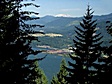
There are a number of hiking destinations that I include in this CD that
are not in the Columbia River Gorge National Scenic Area, and this is one
of them. Bear Lake is accessable from the Columbia River gorge and thus
I include it in this hike guide. There are actually a couple of ways
to reach Bear Lake from the gorge, but I will share the one that begins
at the Wyeth trailhead, located just off Interstate 84 at exit 51.
This is an excellent hike for endurance. After climbing 3840' in the
first four miles, you then keep left at the first junction and
descend 500 ft before regaining the elevation as you
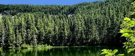
approach North Lake. The climb up the Wyeth Trail offers excellent
vistas of the Columbia River Gorge. North Lake is a shallow little
lake surrounded by forests and the cliffs of Green Point Ridge. Continue
on Trail #411 to the left.
Keep in mind that North Lake, Bear Lake, and Mt. Defiance are all accessable
from a road on the south side which brings you signficantly closer to these
destinations with alot less elevation gain. However, if you'd like to hike
to any one of these destinations from the gorge, you can. When you come to a road,
just bear to the left and follow the signs to Bear Lake. You will lose about 100' in
elevation that you have to regain as you walk back out.
|
|
|
The following images are random samples of the wildflowers found in the Columbia River Gorge National Scenic Area.
Mouseover image to view flower name, and click on image to jump to flower guide.
|
Directions:
From Portland, OR
From Portland, travel east on Interstate Hwy 84 to Exit
Click on the link below to see a map taking you to the trailhead.
|
|
|
|
 |


