THE FOLLOWING MAPS ARE NOT TO BE USED FOR NAVIGATIONAL PURPOSES.
View the slideshow for more sequential photos of this hike.
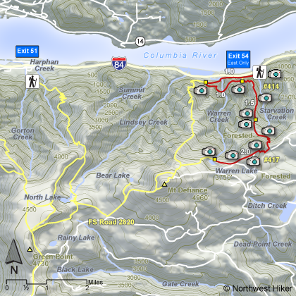
Length: 10 mile RT Elevation Change: 4000' Season: Late spring to early fall Difficulty: Very Difficult due to extreme steepness of trail and length of hike Permit: NW Forest Pass Required Features:
Here is a hike that is even steeper than the Mt. Defiance hike, but not nearly as long.
The hike begins at the same trailhead as the Mt. Defiance and Starvation Creek Loop
hikes. Just pull off of I84 at the Starvation Creek reststop exit. You can park
there and remember to never leave anything of value in your vehicle.... it will get
stolen. The thieves are out of control. Frankly, I never even lock my vehicle anymore.
I figure that I'd rather have them pillage through my jeep and find nothing of value
than break out my window and find nothing of value.
This hike begins like the other two, just walk west along the freeway for about a quarter
of a mile. You will come to a junction on the left which climbs steeply out of the valley.
Follow this steep climb until you intersect another trail in about another half mile or so.
Bear left on this trail and it will take you to Warren Lake.
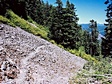
This climb is almost unrelenting and the slight downhill that occurs just before the lake
is more than welcome relief. The lake is beautiful and worth the effort.
I'd encourage you to just return the same way you came. But there is an alternative. You
could cross over and catch the Mt. Defiance trail and follow it back down to your vehicle,
but there are no views worth the effort. Anyway you look at it, the trip back down will
most likely be more difficult than the climb up. You will need very very very good brakes.
The following images are random samples of the wildflowers found in the Columbia River Gorge National Scenic Area.
Mouseover image to view flower name, and click on image to jump to flower guide.


 View the slideshow for more sequential photos of this hike.


 This hike begins like the other two, just walk west along the freeway for about a quarter
of a mile. You will come to a junction on the left which climbs steeply out of the valley.
Follow this steep climb until you intersect another trail in about another half mile or so.
Bear left on this trail and it will take you to Warren Lake.
This climb is almost unrelenting and the slight downhill that occurs just before the lake
is more than welcome relief. The lake is beautiful and worth the effort.
This hike begins like the other two, just walk west along the freeway for about a quarter
of a mile. You will come to a junction on the left which climbs steeply out of the valley.
Follow this steep climb until you intersect another trail in about another half mile or so.
Bear left on this trail and it will take you to Warren Lake.
This climb is almost unrelenting and the slight downhill that occurs just before the lake
is more than welcome relief. The lake is beautiful and worth the effort.


