THE FOLLOWING MAPS ARE NOT TO BE USED FOR NAVIGATIONAL PURPOSES.
View the slideshow for more sequential photos of this hike.
Length: 12.2 RT Elevation Change: 4900' cummulative gain Season: Late spring to early fall Difficulty: Very difficult due
to the steepness of trail and length of hike Permit: NW Forest Pass Required Features:
There are two routes up Mt. Defiance from the Starvation Creek
trailhead. This review takes you up the more gentle of the two.
The hike begins at the freeway reststop exit at Starvation Creek.
The trail actually parallels the freeway westbound for nearly a
mile before the climbing begins. This means that this hike will
climb nearly 5000 feet in five miles. Do you know how to spell
"steep"?
People use this hike to get in shape for more difficult adventures
such as climbing Mt. Everest.... no, I'm kidding. But they do use
it to get in shape for climbing mountains like Hood, Adams, and so
forth. Anyway, you get the idea. This is a very steep and difficult
hike. Be sure you are in shape to attempt this and have plenty
of drinking fluids and noreshments with you. It wouldn't hurt to
have a desent camera with you also to record you last moments on
earth... just kidding.
The trail follows the freeway for about a mile before beginning a grueling 15
switchback climb where the trail kinda levels off for a mile or
so. Then things begin to get steep again to about 4000'. Once you
begin the steep climb you are almost continually in a densely forested
environment.
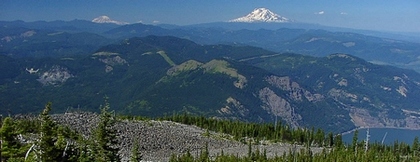
Within a mile of the top you have the opportunity to take a loop
trail the west of the summit and approach the top from the south
side. Return down the north side and meet up with the trail
you came up on. I highly recommend this loop as it affords the
greatest reward for all this effort. Once you summit the mountain
return on the loop and you will reconnect with the trail that
brought you there. I hope you have really really really good
brakes. You WILL need them.
The following images are random samples of the wildflowers found in the Columbia River Gorge National Scenic Area.
Mouseover image to view flower name, and click on image to jump to flower guide.


 View the slideshow for more sequential photos of this hike.