


|
THE FOLLOWING MAPS ARE NOT TO BE USED FOR NAVIGATIONAL PURPOSES.
 View the slideshow for more sequential photos of this hike.
|
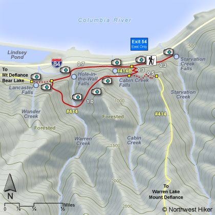
Length: 2.6
mile loop
Elevation Change: 700' gain
Season: Spring thru Fall
Difficulty: Moderate due to extreme steepness of trail
Permit: NW Forest Pass Required
Features: 
Here is an interesting and rewarding little hike right along side
the interstate highway. Just pull off at the Starvation Creek
reststop and trailhead for a fun adventure that will deliver far
more than one would ever imagine. Before you get busy hiking,
however, take a few moments to enjoy Starvation Creek Falls. You
will find it just a short distance beyond the reststop restrooms.
After enjoying the beauty of this wonderful waterfalls, then return
to the trail which parallels the freeway for as much as a mile.
 There are at least three significant waterfalls along this stretch
of the trail, but I recommend that you make a loop out of this hike
and just after you enter the forested part of the trail, you will
find a junction. Bear left and climb steeply up the side of the
gorge. It is very steep, but it isn't a very long climb and well
worth it. In season there are wonderful floral displays all along
this fun trail. Hole-in-the-wall falls(left) is also called Warren
Falls.
There are at least three significant waterfalls along this stretch
of the trail, but I recommend that you make a loop out of this hike
and just after you enter the forested part of the trail, you will
find a junction. Bear left and climb steeply up the side of the
gorge. It is very steep, but it isn't a very long climb and well
worth it. In season there are wonderful floral displays all along
this fun trail. Hole-in-the-wall falls(left) is also called Warren
Falls.
This can
be an easy gentle walk to a number of lovely waterfalls.
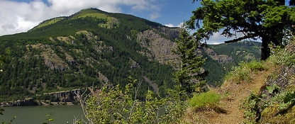
However, if you decide to do the upper loop, then be prepared for an
extremely steep trail. The loop trail takes you high above the
freeway to a number of overlooks with excellent views of the
Columbia River Gorge. Wildflowers abound in spring and early
summer. Be very careful
as part of this trail is EXTREMELY STEEP.
|
|
|
The following images are random samples of the wildflowers found in the Columbia River Gorge National Scenic Area.
Mouseover image to view flower name, and click on image to jump to flower guide.
|
Directions:
From Portland, OR
From Portland, travel east on Interstate Hwy 84 to Exit
Click on the link below to see a map taking you to the trailhead.
|
|
|
|
 |


