


|
THE FOLLOWING MAPS ARE NOT TO BE USED FOR NAVIGATIONAL PURPOSES.
 View the slideshow for more sequential photos of this hike.
|
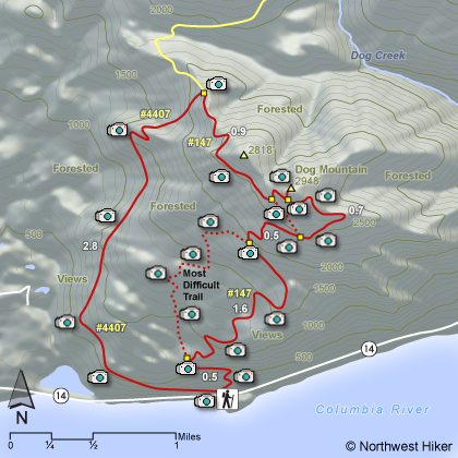
Length: 7 mile loop, give or take
Elevation Change: 2800' gain
Season: Spring thru Fall with occasional winter opportunities
Difficulty: Difficult due to steepness of trail
Permit: NW Forest Pass Required
Features: 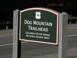
Dog Mountain is one of the most hiked destinations in the
Columbia River Gorge. It is accessable nearly year round
and offers three different routes to the summit. Because
it is so popular, one might plan to do all three routes
over time just for the fun of it. Not all mountains offer
this option.
The map and mouse-over photos will give you an idea of what
each of the different routes are like. The far west side
route is the easiest, even though it is the longest. The
far east side route is second easiest. And the middle route
is the most difficult because it is the most steep.
 The most enjoyable time of the year to climb Dog Mountain is
during the last half of May and the first half of June. The
beautiful balsamroot wildflowers are in bloom then and cover
the mountain in a blanket of yellow. Other beautiful flowers
add to the bouquet of joy.
The most enjoyable time of the year to climb Dog Mountain is
during the last half of May and the first half of June. The
beautiful balsamroot wildflowers are in bloom then and cover
the mountain in a blanket of yellow. Other beautiful flowers
add to the bouquet of joy.
I personally find winter the second most enjoyable time to
climb Dog Mountain. It is usually snowing on the top third
of the mountain when it is raining at the trailhead. Climbing
up into the snow is fun and sometimes challenging. Always hike
prepared for difficult weather, even in the summer. You just
never know what you might encounter.
 An excellent hike up a fairly steep mostly forested mountain to the
open vistas of the top. In season (late May thru June) the
floral displays are among the best. The trailhead parking lot is
very large for a hiking area, which attests to the popularity of
this hike. There are three basic ways to climb Dog Mtn, and this
narrative is going to share the loop. If you start out on the
Augspurger Trail near the middle of the parking lot, you will find
an easier climb but a steeper descent. Whatever way you choose,
you will find this a spectacular hike for sure.
An excellent hike up a fairly steep mostly forested mountain to the
open vistas of the top. In season (late May thru June) the
floral displays are among the best. The trailhead parking lot is
very large for a hiking area, which attests to the popularity of
this hike. There are three basic ways to climb Dog Mtn, and this
narrative is going to share the loop. If you start out on the
Augspurger Trail near the middle of the parking lot, you will find
an easier climb but a steeper descent. Whatever way you choose,
you will find this a spectacular hike for sure.

|
|
|
The following images are random samples of the wildflowers found in the Columbia River Gorge National Scenic Area.
Mouseover image to view flower name, and click on image to jump to flower guide.
|
Directions:
From Portland, OR
From Portland, travel east on Interstate Hwy 84 to Exit
Click on the link below to see a map taking you to the trailhead.
|
|
|
|
 |


