|
|


|
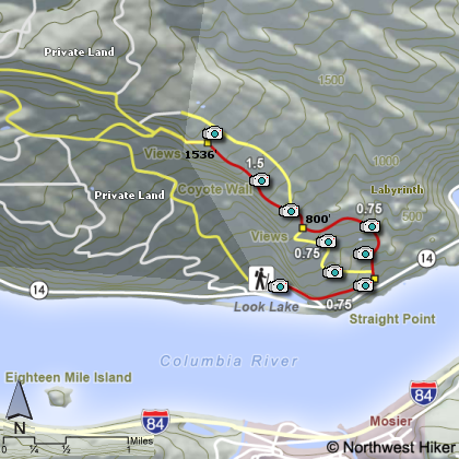
THE FOLLOWING MAPS ARE NOT TO BE USED FOR NAVIGATIONAL PURPOSES.
 View the slideshow for more sequential photos of this hike.
|
Length: 6 miles RT
Elevation Change: 1550 feet
Season: Late winter thru late fall
Difficulty: Challenging
Permit: Pass Not Required
Features: 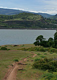
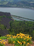
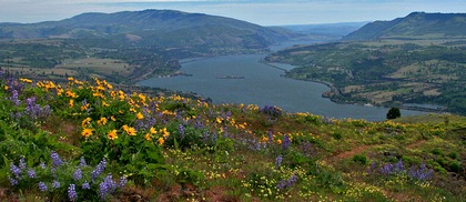
The Coyote Wall sincline is an exceptional place to hike if you like
open spaces and steep cliffs with great vistas. Then add to this
extraordinary floral displays and you have one of the best places
to hike in the gorge. As of this writing, there are no designated
trails in this area, but I will share with you a hike that most
likely will become a designated route in the years to come. Due
to the extreme popularity amongst mountain bikers, this place
has become very well known. Hikers too enjoy the great rewards.
 I chose to park at the trailhead shown on the map at the western
corner of this hiking area, just off SR14 at Look Lake. Then you
walk the old closed highway 14 east for about a half mile. You
will then see the trailheading off on the left up the mountain.
At this point you will have several options. I suggest that you
take the middle trail and head uphill, straight ahead. This
trail will eventually end up in the same place as the option on
your left, which is a road that works its way up Coyote Wall.
I chose to park at the trailhead shown on the map at the western
corner of this hiking area, just off SR14 at Look Lake. Then you
walk the old closed highway 14 east for about a half mile. You
will then see the trailheading off on the left up the mountain.
At this point you will have several options. I suggest that you
take the middle trail and head uphill, straight ahead. This
trail will eventually end up in the same place as the option on
your left, which is a road that works its way up Coyote Wall.
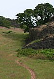
 This trail up Coyote Wall climbs past rocky outcroppings, small
streams, and waterfalls, and under large old oak trees. Eventually,
the trail meets up with the road you did not choose earlier. From
here on you can clearly see where most people hike. It gets pretty
steep here, but take your time and enjoy the incredible views all
around you. In the spring and early summer you can the joy of
being surrounded by a sea of wildflowers.
This trail up Coyote Wall climbs past rocky outcroppings, small
streams, and waterfalls, and under large old oak trees. Eventually,
the trail meets up with the road you did not choose earlier. From
here on you can clearly see where most people hike. It gets pretty
steep here, but take your time and enjoy the incredible views all
around you. In the spring and early summer you can the joy of
being surrounded by a sea of wildflowers.
It is in my nature to return via a different route on any hike
if it is possible. Well, here you can return via the old road
that you did not choose earlier while climbing the wall.
|
|
|
The following images are random samples of the wildflowers found in the Columbia River Gorge National Scenic Area.
Mouseover image to view flower name, and click on image to jump to flower guide.
|
Directions:
From Portland, OR
From Portland, travel east on Interstate Hwy 84 to Exit
Click on the link below to see a map taking you to the trailhead.
|
|
|
 |
|
|


