THE FOLLOWING MAPS ARE NOT TO BE USED FOR NAVIGATIONAL PURPOSES.
View the slideshow for more sequential photos of this hike.
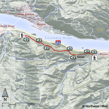
Length: 9 miles round trip Elevation Change: 300 feet Season: Late winter thru late fall Difficulty: Moderate Permit: NW Forest Pass Required Features:
I call this the Moiser Tunnel hike, but most refer to it as the
Historic Columbia River State Trail. A project that was completed
in 2000 to restore a portion of the old Columbia River highway to
its original condition between Hood River and Mosier. Today, hikers
and bike riders enjoy this unique paved trail most anytime during
the year. Winter conditions can make the trail impassable.
One can start at either end of this 4.5 mile trail. I consider
beginning at the east end the better option in that you only need
to hike about .75 miles to come to the tunnel system for which
the entire hike is famous. I recommend hiking only half way
along this road, unless you have shuttle sytem in place to
pick you up at the other end. There is really no great reward
in hiking the entire 4.5 miles from one end to the other, only
to have to retrace the 4.5 miles back to your vehicle.
This hike is unique. It is certain worth doing. And the
reward is not only the very unique tunnel system, but the
incredible views of the Columbia River Gorge and in season
the wonderful foral displays. It is easy enough for the
very young and/or the elderly.
The following images are random samples of the wildflowers found in the Columbia River Gorge National Scenic Area.
Mouseover image to view flower name, and click on image to jump to flower guide.


 View the slideshow for more sequential photos of this hike.


 One can start at either end of this 4.5 mile trail. I consider
beginning at the east end the better option in that you only need
to hike about .75 miles to come to the tunnel system for which
the entire hike is famous. I recommend hiking only half way
along this road, unless you have shuttle sytem in place to
pick you up at the other end. There is really no great reward
in hiking the entire 4.5 miles from one end to the other, only
to have to retrace the 4.5 miles back to your vehicle.
One can start at either end of this 4.5 mile trail. I consider
beginning at the east end the better option in that you only need
to hike about .75 miles to come to the tunnel system for which
the entire hike is famous. I recommend hiking only half way
along this road, unless you have shuttle sytem in place to
pick you up at the other end. There is really no great reward
in hiking the entire 4.5 miles from one end to the other, only
to have to retrace the 4.5 miles back to your vehicle.
 This hike is unique. It is certain worth doing. And the
reward is not only the very unique tunnel system, but the
incredible views of the Columbia River Gorge and in season
the wonderful foral displays. It is easy enough for the
very young and/or the elderly.
This hike is unique. It is certain worth doing. And the
reward is not only the very unique tunnel system, but the
incredible views of the Columbia River Gorge and in season
the wonderful foral displays. It is easy enough for the
very young and/or the elderly.


