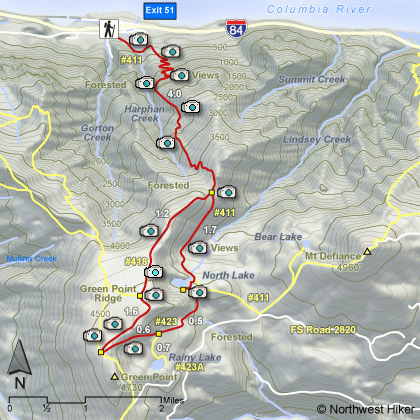
Length: 15 miles including Rainy Lake loop
Elevation Change: 4400' gain
Season: Midsummer thru Fall
Difficulty: Very Difficult due to steepness and
length of hike
Permit: NW Forest Pass Required
Features:
This is an excellent hike for endurance. Yet, it is also an excellent adventure hike.
The trail begins at the Wyeth Campground trailhead. Just follow the main trail out of
the parking area for a short distance, until it comes to a junction with Gorge Trail #400.
Make a sharp left at this point and continue on Trail #411.
You will have to cross a major stream within a short distance, and depending on the time
of year, this could be a bit of a challenge. After crossing the stream, the trail wanders
for just a bit before picking up steam and starting the incredible 1000 feet per mile ascent
up Wyeth Ridge.
After climbing 3840' in the first four miles, you then keep left and
descend 500 ft before regaining the elevation as you
approach North Lake. The climb up the Wyeth Trail offers excellent
vistas of the Columbia River Gorge. North Lake is a shallow little
lake surrounded by forests and the cliffs of Green Point Ridge.
At this junction, bear right and climb steeply up Green Point Ridge.
The trail then levels off for about a mile as you walk through dense
forests. You will come to the junction of the Gordon Creek trail, but
just continue south on Trail #418.
Shortly you will notice that by walking just a short distance off the
trail to the left (east) you can catch an excellent view of North Lake
below you and Mt. Defiance in the distance.
The southern exposure of Green Point Ridge does offer some excellent
views of Mt Hood, Rainy Lake, and the surrounding terrain. As
you return from Rainy Lake, you will hike past North Lake, and then
continue to loose elevation for a while before climbing back up to
4000' just in time to descend 3840' back to the trail head.
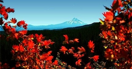 Looking south at Mt Hood from the Green Point trail
|