|
|
THE FOLLOWING MAP IS NOT TO BE USED FOR NAVIGATIONAL PURPOSES.
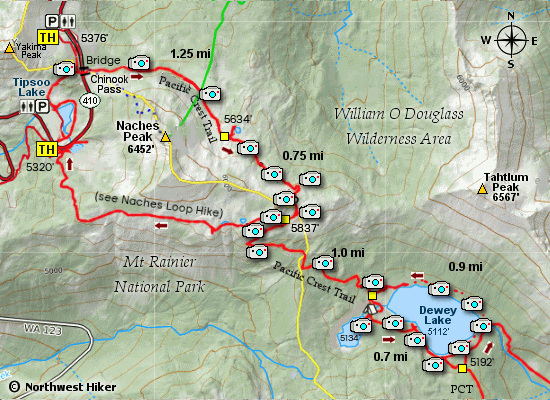
MAP OF THE DEWEY LAKES HIKE
|
Length: 7.6 miles round trip
Elevation Change: 1337' gain
Season: Summer thru fall
Difficulty: Challenging
Permit: NW Forest Pass Required
Latitude: 46.8753
Longitude: -121.5173
Features:
This is a popular hike that is richly
rewarded. The hike can be accessed by either the trailhead
near Tipsoo Lake or the one on Chinook Pass. I recommend the
trailhead at Chinook Pass and returning via the Tipsoo Lake
trailhead.
From the parking area near Chinook Pass, you will cross HWY 410 on a
very substantial bridge for the Pacific Crest Trail, which you will
follow all the way to Dewey Lake.
For the first two miles you will essentially be hiking what is popularly
known as the Naches's Loop trail. Then you will come to a junction that
will diverge from the "loop" and take you via the PCT down to Dewey Lake.
The next mile is rather steep, which is no problem going down.... but ....
a bit of a challenge climbing back out of the valley where the lake is
located.
As you near Dewey Lake you will come to a few user trails on the left
and then after crossing a bridge over a small outlet stream from the
upper Dewey Lake, there is an obvious trail to your right which takes
you to the upper lake. This option is so worth while!
Returning to the PCT, continue east for another 0.7 miles to a junction
off the PCT on the left. You will want to follow this Trail 968 for a
short distance and then follow a user trail to the left which will take
you around the north side of the lake.
Once you return to the PCT, bear to the right and begin your climb
out of the valley for another 0.7 miles. When you reach the junction
which you earlier navigated, bear to the left and follow this trail,
which is within the Mt. Rainier National Park, down to Tipsoo Lake.
Follow the trail around the lake and then back up to Chinook Pass to
return to your vehicle.

The eastern end of Dewey Lake with Tahtlum Peak on the right
|
|
How to get there:
Trailhead: N46.8753, W121.5173 (click for directions)
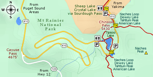
From the Yakima, WA area travel on Hwy 12 about 4.5 miles west of Naches, WA.
Hwy 12 will then turn left, but you keep straight ahead on Hwy 410. Follow Hwy 410
for another 47 miles and you will come to a trailhead parking area on your right.
This trailhead connects to the Pacific Crest Trail, which for our purposes offers
two hikes. One to the north to Sheep Lake and Crystal Lake, and one to the south
to the Naches Loop Trail.
Coming from the northwest follow Hwy 410 from Enumclaw, WA for about 41 miles
then turn left and follow Hwy 410 up to Chinook Pass. Just a bit further on your
left will be this major trailhead.
Coming from the southwest follow Hwy 12 to the junction of Hwy 123. Turn left
onto Hwy 123 and follow it the junction with Hwy 410. Then turn right and
follow Hwy 410 up to Chinook Pass. Just a bit further on your left will be
this major trailhead.
|
|


