Methow RDe Chelan RD Entiat RD Wenatchee RD Cle Elum RD Naches RD National Foest
Okanogan-Wenatchee National Forest
Methow Ranger District

Cedar Falls Hike


Click on above image to return to graphic


Click to view product details


National Forest
Annual Pass
Oregon and Washington


Washington State
Discovery Pass


Oregon State
Recreation Passes

THE FOLLOWING MAP IS NOT TO BE USED FOR NAVIGATIONAL PURPOSES.

MAP OF THE CEDAR FALLS HIKE


Topo Map

Profile

Slide Show


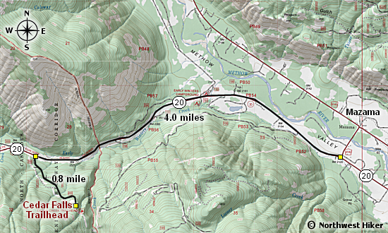
Length: 3.5 miles round trip
Elevation Change: 717' gain
Season: Summer thru fall
Difficulty:   Moderate
Permit:
  NW Forest Pass Required
Latitude:   48.5806
Longitude:   -120.4763

Features:

Here's a little gem of a hike which takes you up Cedar Creek to a nice little falls. The trail is well maintained and fairly gentle, while only climbing a little over 500' in the 2 miles to get there.

Of course depending on what time of year you hike this trail will determine how much water is flowing over the falls. In the early summer the water is high and in some ways the falls aren't as pretty. In the late summer and fall you can get really fun photos of the falls and the surrounding cascades.


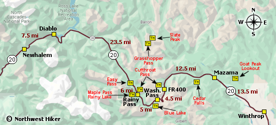
A surprise near the trailhead to Cedar Falls


How to get there:

   Trailhead:   N48.5806, W120.4763 (click for directions)  


Hike Difficulty Calculator

Calorie Burn Calculator

The 10 Essentials
Bear Encounters

Cougar Encounters

River Crossing Safety

A Virtual Hike of the Okanogan-Wenatchee National Forest


Click to View Instructions