Methow RDe Chelan RD Entiat RD Wenatchee RD Cle Elum RD Naches RD National Foest
Okanogan-Wenatchee National Forest
Naches Ranger District

Cramer Lake Hike


Click on above image to return to graphic


Click to view product details


National Forest
Annual Pass
Oregon and Washington


Washington State
Discovery Pass


Oregon State
Recreation Passes

THE FOLLOWING MAP IS NOT TO BE USED FOR NAVIGATIONAL PURPOSES.

MAP OF THE CRAMER LAKE HIKE


Topo Map

Profile

Slide Show


Length: 6.67 miles round trip
Elevation Change: 1031' gain
Season: Summer thru fall
Difficulty:   Moderate
Permit:
  NW Forest Pass Required
Latitude:   46.6456
Longitude:   -121.3822

Features:

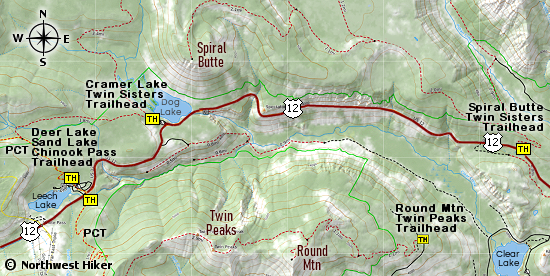
This hike begins at the Dog Lake camp area.

This trail takes you to Cramer Lake but it continues on to several other destinations, such as Tumac Mountain and Twins Sisters Lakes.

At about 1.25 miles, the trail crosses the North Fork of Clear Creek. The bridge washed out a long time ago, so you will have to wade the creek.

After the creek, the trail begins to climb gently out of the valley, and in another 2 miles you will come to Cramer Lake.


Cramer Lake


How to get there:

   Trailhead:   N46.6456, W121.3822 (click for directions)  


Hike Difficulty Calculator

Calorie Burn Calculator

The 10 Essentials
Bear Encounters

Cougar Encounters

River Crossing Safety

A Virtual Hike of the Okanogan-Wenatchee National Forest


Click to View Instructions