Methow RDe Chelan RD Entiat RD Wenatchee RD Cle Elum RD Naches RD National Foest
Okanogan-Wenatchee National Forest
Naches Ranger District

Edgar Rock West Approach Hike


Click on above image to return to graphic


Click to view product details


National Forest
Annual Pass
Oregon and Washington


Washington State
Discovery Pass


Oregon State
Recreation Passes

THE FOLLOWING MAP IS NOT TO BE USED FOR NAVIGATIONAL PURPOSES.

MAP OF THE EDGAR ROCK HIKE


Topo Map

Profile

Slide Show


Length: 3.8 miles round trip
Elevation Change: 827' gain
Season: Summer thru fall
Difficulty:   Moderate
Permit:
  NW Forest Pass Required
Latitude:   46.9235
Longitude:   -121.0866

Features:

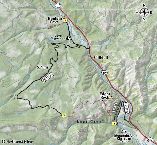
This hike is used mostly by motor and mountain bikers as a through hike to the beginning of the Edgar Rock trail on the Lost Creek trailhead. This option does offer a shuttle hike for those who care.

The trail crosses a couple of old logging roads along the way, but for the most part it follows east the join up with the Lost Creek trail to the summit of Edgar Rock.

In season, you will be presented with an abundance of wildflowers. The trail is seldom used and a bit sketchy at times.


Looking east from the Edgar Rock trail


How to get there:

   Trailhead:   N46.9235, W121.0866 (click for directions)  


Follow FR 1706 for approximately 5.7 miles to the western approach trailhead.

Hike Difficulty Calculator

Calorie Burn Calculator

The 10 Essentials
Bear Encounters

Cougar Encounters

River Crossing Safety

A Virtual Hike of the Okanogan-Wenatchee National Forest


Click to View Instructions