Length: 4 miles round trip
Elevation Change: 1198' gain
Season: Summer thru fall
Difficulty: Challenging
Permit: NW Forest Pass Not Required
Latitude: 46.9175
Longitude: -121.2331
Features:
This is a seldom used trail, but it offers a fun adventure and several
world class views. Getting to the trailhead can be a bit challenging,
but it is worth it. In season the wildflowers are outstanding.
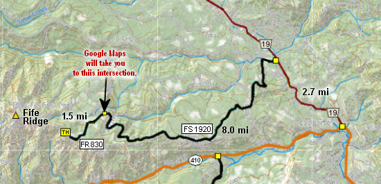
To access the main trail that runs the full length of Fife Ridge, you
will start at the access at the end of the FR830, which is an extension
of FR1920. The trail begins rather steeply as it climbs to meet the
actual Fife Ridge Trail.
Within a very short distance, the trail breaks out of forest with great
views to the west of Mt. Rainier and the Fife ridge itself. The trail
climbs a bit steeply from time to time, but generally, it isn't too bad.
About a mile into the hike, the trail descends into a heavily forested
area with a small stream before climbing up out into the open again.
At this point, I have encountered US Navy jets flying low level practice
runs in the valley just below this area.
As the trail climbs, it is in and out of lightly forested areas, offering
excellent views of the Stuart Range to the north and Mt. Adams to the south.
When you reach the high point of the hike, there are outstanding views of
Mt. Rainier to the west.

Looking west at Mt Rainier from the Fife Ridge trail
|