Length: 10.5 miles round trip
Elevation Change: 2375' gain
Season: Summer thru Fall
Difficulty: Difficult
Permit: NW Forest Pass Required
Latitude: 48.4395
Longitude: -120.5305
Features:
This is another exceptional hike on the east side of the North Cascades National Park boundary.
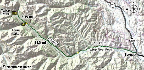
Access is via Twisp, Washington, as indicated below, and it is very easy to reach the trail head. The main
trail #401 can be taken to other exciting destinations, many of which are in the NCNP. But for
this hike, one just gets to wallow in the beauty of raw wilderness.
The hike leaves the parking area and descends to cross the Twisp River over a sturdy bridge fit for a horse.
Horse traffic on this trail is common and a great way to see back country wilderness. For us, though,
the trail will take us to places so beautiful they are difficult to adequately describe.
After crossing the bridge, the trail climbs and heads south-southwest up the valley of South Creek.
As you hike along the creek, you gain elevation which affords you ever increasing vistas of the
surrounding peaks and valleys.
At about 2 miles you will come to the junction of Trail #428, the trail to Louis Lake. Upon leaving
Trail #401, you descend to cross South Creek on a fine wooden bridge, but after crossing the creek,
you begin a long, steady climb up into the Louis Creek valley, which leads to the lake.
The trail climbs, occassionally rather steeply, as you continue toward the lake. There are wonderful
vistas along the way and in season there are beautiful floral displays. In late summer, there are
also delicious berries to enjoy along the trail.
Just before you reach the lake, the trail crosses Louis Creek on a single log bridge. After crossing,
it is but a short distance to the lake. Oh, by the way, just before reaching the lake, hidden in the
bushes on your right, is a fine outhouse without walls for your use.
When you do get to the lake, there is a large log jam in the outlet of the lake, making for a less
picturesque view. So, just walk along the user trail on the left (or north) side of the lake until
you come to a place that offers the kind of view you were hoping for.... because it is there....
waiting for you and your camera!

Panorama view of Louis Lake
|