|
Features:
 This is a very popular hike in the Mt. Rainier National Park because of its
easy access and its world class views. This hike uses the very popular
Wonderland Trail and the first 2 miles it is almost wide enough to
walk side by side.
This is a very popular hike in the Mt. Rainier National Park because of its
easy access and its world class views. This hike uses the very popular
Wonderland Trail and the first 2 miles it is almost wide enough to
walk side by side.
One of the greatest challenges to enjoying this hike, is finding a place
to park at the designated trailhead. On a weekend, if you arrive after
7am, you may not find a place to park.
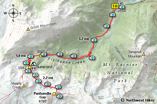
For the first mile, the trail is relatively level, but then it gradually begins to climb.
At about 2 miles, the trail crosses Fryingpan Creek on a log bridge with a railing to hold on to.
After crossing the creek, the trail begins its serious climb by several well placed
switchbacks. In about another mile, the trail intersects a couple of serious options.
 To the left, or east, are trails to the designated camp areas and toilet facilities.
To the righ, or west, is a trail that leads to several destinations, including Little Tahoma.
To reach Panhandle Gap, just remain on the Wonderland Trail. The next two miles are
the most challenging of this hike. The trail is steeper and it crosses a significant
meltwater stream on its way to the Gap.
To the left, or east, are trails to the designated camp areas and toilet facilities.
To the righ, or west, is a trail that leads to several destinations, including Little Tahoma.
To reach Panhandle Gap, just remain on the Wonderland Trail. The next two miles are
the most challenging of this hike. The trail is steeper and it crosses a significant
meltwater stream on its way to the Gap.
Most of the summer there are snow fields to cross but nothing technical. Just before
reaching the Gap, there is a rather steep snowfield to navigate and one should use
intelligent caution so as to not slip down the slop and have to reclimb it. Once you
reach Panhandle Gap, on a clear day you will be greeted with awesome views of the mountains
south of Mt. Rainier.... Mt. Adams, the Goat Rocks, and even Mt. Hood.
 The day we hiked to the Gap, we were treated to over 3 dozen mountain goats in 2 different groups.
Mountain Goats love to lay on the snow when it is hot and in this case, they got up to
to move to the clear area just beside the snowdrift.
The day we hiked to the Gap, we were treated to over 3 dozen mountain goats in 2 different groups.
Mountain Goats love to lay on the snow when it is hot and in this case, they got up to
to move to the clear area just beside the snowdrift.

Mt. Rainier from Panhandle Gap
|


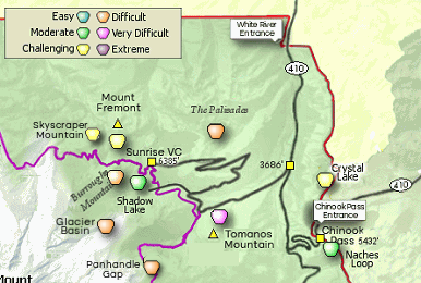


 The Panhandle Gap trail begins at the bridge that crosses Frying Pan Creek about 6.75 miles west of
SR 410 on the Sunrise Park Road.
The Panhandle Gap trail begins at the bridge that crosses Frying Pan Creek about 6.75 miles west of
SR 410 on the Sunrise Park Road.
