Methow RDe Chelan RD Entiat RD Wenatchee RD Cle Elum RD Naches RD National Foest
Okanogan-Wenatchee National Forest
Naches Ranger District

Sheep Lake and Sourdough Gap Hike


Click on above image to return to graphic


Click to view product details


National Forest
Annual Pass
Oregon and Washington


Washington State
Discovery Pass


Oregon State
Recreation Passes

THE FOLLOWING MAP IS NOT TO BE USED FOR NAVIGATIONAL PURPOSES.

MAP OF THE SHEEP LAKE AND SOURDOUGH PASS HIKE


Topo Map

Profile

Slide Show


Length: 6.0 miles round trip
Elevation Change: 1230' gain
Season: Summer thru fall
Difficulty:   Challenging
Permit:
  NW Forest Pass Required
Latitude:   46.8753
Longitude:   -121.5173

Features:

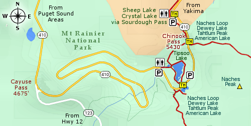
The trailhead is located at a fine parking area just a short distance east of Chinook Pass and is complete with a couple of restrooms, which are over used on the weekends.... so, Monday's they are pretty useless. This entire hike is part of the Pacific Crest Trail.

Near the north end of the parking area, next to the restroom facilities, there is a short steep trail that takes you to the main PCT. Follow this incredible trail in a gentle descent for about 3/4 of mile, then it begins to gently climb. Just a little over mile into the hike, the trail makes a sharp left turn and climbs more vigorously to Sheep Lake.

You will come to a few side trails along the way, but just stay on the obviously used trail to the lake itself. Then follow the trail to the right around the lake, over a small wooden bridge, and then uphill towards Sourdough Pass.

The climb up to Sourdough Pass is steep in places, but it is well worth it. As you start climbing, there will be several opportunities to enjoy world class views to the south, including Mt. Adams and Mt. St. Helens. As you near the pass, you will get glimpses of the top of Mt. Rainier to the west.

And, of course, in season, there will be lots of wildflowers.


Looking west across Sheep Lake


How to get there:

   Trailhead:   N46.8753, W121.5173 (click for directions)  


From the Yakima, WA area travel on Hwy 12 about 4.5 miles west of Naches, WA. Hwy 12 will then turn left, but you keep straight ahead on Hwy 410. Follow Hwy 410 for another 47 miles and you will come to a trailhead parking area on your right. This trailhead connects to the Pacific Crest Trail, which for our purposes offers two hikes. One to the north to Sheep Lake and Crystal Lake, and one to the south to the Naches Loop Trail.

Coming from the northwest follow Hwy 410 from Enumclaw, WA for about 41 miles then turn left and follow Hwy 410 up to Chinook Pass. Just a bit further on your left will be this major trailhead.

Coming from the southwest follow Hwy 12 to the junction of Hwy 123. Turn left onto Hwy 123 and follow it the junction with Hwy 410. Then turn right and follow Hwy 410 up to Chinook Pass. Just a bit further on your left will be this major trailhead.


Hike Difficulty Calculator

Calorie Burn Calculator

The 10 Essentials
Bear Encounters

Cougar Encounters

River Crossing Safety

A Virtual Hike of the Okanogan-Wenatchee National Forest


Click to View Instructions