Length: 8.5 miles round trip
Elevation Change: 2698' gain
Season: Summer thru fall
Difficulty: Difficult
Permit: NW Forest Pass Required
Latitude: 46.7160
Longitude: -121.1657
Features:
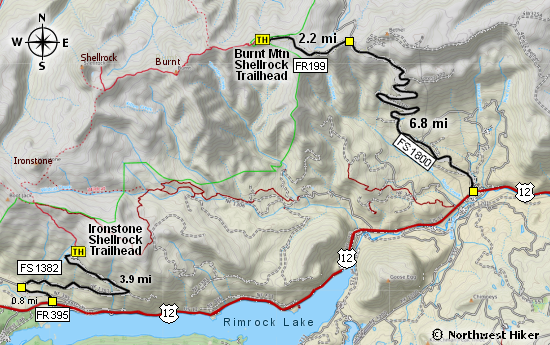
There are two main ways to climb Shellrock Mountain. One way is to take the Ironstone
Mountain trail from the south and the other way is to take the Burnt Mountain trail
from the east. I will present the eastern approach in this presentation.
This hike is entirely within the William O. Douglas Wilderness, so you
must sign in at the trail head. After a short walk, you will come to the
first of many fantastic viewpoints, where you see Mt. Adams to the south,
and Mt. Rainier to the west. After this, the trail drops steeply for a
couple hundred feet, so watch you footing.
The trail number is 1141, and it is called the Iron Mountain Trail, because
the trail does eventually reach Iron Mountain, but not in this description.
About half way to Burnt Mountain, you will come to a junction of a trail
referred to as the Burnt Mountain Tail #1140. Nevertheless, you will continue
on Trail 1141 to Burnt Mountain.
The trail losses elevation as you hike toward Burnt Mountain, but when you reach
the base of the mountain, the trail climbs very steeply up onto the southern
shoulder of the peak. There is a user trail to the summit of Burnt Mtn, but you
can continue on westward toward Shellrock Mountain. For the next nile or so, you
will be treated to fantastic views of Mt. Rainier and other peaks in the area.
About a mile and a half from the Burnt Mtn junction, you will come to a junction
that leads to the summit of Shellrock. Bear right and follow this trail for another
three quarters of a mile to the summit. Needless to say, this last stretch of the
hike offers world class views of Mt. Rainier to the west, and Mt. Adams with the
Goat Rocks to the south.

Trail shot on the Shellrock Mountain trail
|