THE FOLLOWING MAPS ARE NOT TO BE USED FOR NAVIGATIONAL PURPOSES.
View the slideshow for more sequential photos of this hike.
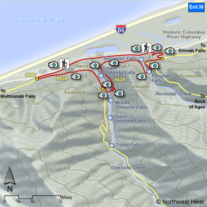
Length: 2.3 mile loop Elevation Change: 440' gain Season: Year Round Difficulty: Easy Permit: No Pass Required Features:
This loop hike can be done clockwise or counterclockwise.
You can begin the hike at either Horsetail Falls trailhead or the Oneonta Gorge
trailhead. This narrative will begin at Horsetail Falls. The trail begins at
the east end of the viewing area for Horsetail Falls. You begin climbing
immediately for a short distance where you hook up with Gorge Trail #400. Bear
right and follow this trail west for about a half mile to the beautiful Ponytail Falls.
You are rewarded not only with its beauty but by being able to walk behind the falls as
you continue your hike around this loop adventure. Another half mile and you come
to Oneonta Gorge with a superb bridge spanning the chasm formed by Oneonta Creek.
Middle Oneonta Falls is on the south side of the bridge, and if you
look downstream you are looking at the top of Lower Oneonta Falls,
which is only visible by hiking up Oneonta Gorge.
After crossing the creek, you begin a brief steep climb and continue west for about another half
mile. A trail will lead you back down to the Old Columbia River Highway and a
short half mile walk along the highway past Oneonta Gorge to Horsetail Falls.
The following images are random samples of the wildflowers found in the Columbia River Gorge National Scenic Area.
Mouseover image to view flower name, and click on image to jump to flower guide.


 View the slideshow for more sequential photos of this hike.


 This loop hike can be done clockwise or counterclockwise.
You can begin the hike at either Horsetail Falls trailhead or the Oneonta Gorge
trailhead. This narrative will begin at Horsetail Falls. The trail begins at
the east end of the viewing area for Horsetail Falls. You begin climbing
immediately for a short distance where you hook up with Gorge Trail #400. Bear
right and follow this trail west for about a half mile to the beautiful Ponytail Falls.
This loop hike can be done clockwise or counterclockwise.
You can begin the hike at either Horsetail Falls trailhead or the Oneonta Gorge
trailhead. This narrative will begin at Horsetail Falls. The trail begins at
the east end of the viewing area for Horsetail Falls. You begin climbing
immediately for a short distance where you hook up with Gorge Trail #400. Bear
right and follow this trail west for about a half mile to the beautiful Ponytail Falls.
 You are rewarded not only with its beauty but by being able to walk behind the falls as
you continue your hike around this loop adventure. Another half mile and you come
to Oneonta Gorge with a superb bridge spanning the chasm formed by Oneonta Creek.
Middle Oneonta Falls is on the south side of the bridge, and if you
look downstream you are looking at the top of Lower Oneonta Falls,
which is only visible by hiking up
You are rewarded not only with its beauty but by being able to walk behind the falls as
you continue your hike around this loop adventure. Another half mile and you come
to Oneonta Gorge with a superb bridge spanning the chasm formed by Oneonta Creek.
Middle Oneonta Falls is on the south side of the bridge, and if you
look downstream you are looking at the top of Lower Oneonta Falls,
which is only visible by hiking up  After crossing the creek, you begin a brief steep climb and continue west for about another half
mile. A trail will lead you back down to the Old Columbia River Highway and a
short half mile walk along the highway past Oneonta Gorge to Horsetail Falls.
After crossing the creek, you begin a brief steep climb and continue west for about another half
mile. A trail will lead you back down to the Old Columbia River Highway and a
short half mile walk along the highway past Oneonta Gorge to Horsetail Falls.


