Summary:
Press CTRL + P to print. Photos do not show when you print this page. (Help)
 As is obvious, there are a couple of ways to do the Gunsite Ridge - Badger Lake Loop. Because
I've already covered the Gumjuwac Saddle hike on this CD (see Hike 44),
I'll write this narrative from Gumjuwac Saddle.
As is obvious, there are a couple of ways to do the Gunsite Ridge - Badger Lake Loop. Because
I've already covered the Gumjuwac Saddle hike on this CD (see Hike 44),
I'll write this narrative from Gumjuwac Saddle.
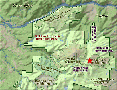
Leave the parking area walking south on Trail #458 and follow Gunsite Ridge for nearly 3.5 miles.
The trail climbs immediately in dense forest and takes you through a couple of switchbacks.
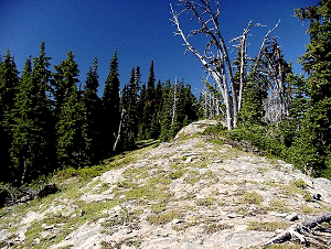
Soon you come to a more open area with the ridge clearly exposed to your right. Leave the
trail and climb up to the ridge at your pleasure and enjoy the fine vistas offered.
The trail along Gunsite Ridge offers several opportunities like this as you hike along.
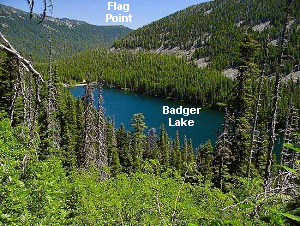
At about a mile and a half the trail comes out onto Forest Road #3550. Walk across the
road and enjoy the magnificent view of Badger Lake below you and Mt Jefferson to the
south. You'll have to walk the road for a few hundred feet before the trail picks up
on your right. Follow the trail just a short distance and you will be treated to more
fantastic views of Mt Jefferson to the south, Mt Adams and Mt Rainier to the north, and
of course wonderful Mt Hood to your west.
 For the next couple of miles you will wander in and out of timbered areas and mountain
meadows. In season the flowers are just fine on this hike. You will begin to descend
and come to the junction of Trail #458 and Trail #478. Bear left, and follow #478 down
the hill until you cross Forest Road 3550. It is a bit difficult to re-find the trail
and you may need to walk uphill just a bit, keeping a look off to your right. The trail
is there, but not very well defined. Once you establish the trail, follow it until it
once again comes out on a Forest Service road #4860. You will come out on the road
right at the trailhead for Badger Lake, so just locate Trail #479 and begin your descent
to Badger Lake.
For the next couple of miles you will wander in and out of timbered areas and mountain
meadows. In season the flowers are just fine on this hike. You will begin to descend
and come to the junction of Trail #458 and Trail #478. Bear left, and follow #478 down
the hill until you cross Forest Road 3550. It is a bit difficult to re-find the trail
and you may need to walk uphill just a bit, keeping a look off to your right. The trail
is there, but not very well defined. Once you establish the trail, follow it until it
once again comes out on a Forest Service road #4860. You will come out on the road
right at the trailhead for Badger Lake, so just locate Trail #479 and begin your descent
to Badger Lake.
As you descend you will find several springs along the trail. This causes the plants
to grow vigorously and you may need to claw your way through them. However, it isn't
difficult and offers less challenge than the 2000 logs you'll need to crawl over as
you make your way down the mountain. Did I say, 2000, I meant 20 or so.... I think.
 In about a mile and a quarter you will come to the intersection of Trails #479 and #458.
Bear to the right and follow #458 down to the lake. It is only about two tenths of a
mile. Enjoy the lake area, then prepare for the climb back out of the valley and back
up to Gumjuwac Saddle.
In about a mile and a quarter you will come to the intersection of Trails #479 and #458.
Bear to the right and follow #458 down to the lake. It is only about two tenths of a
mile. Enjoy the lake area, then prepare for the climb back out of the valley and back
up to Gumjuwac Saddle.
Just follow Trail #458 back up the mountain. You will cross a number of small streams
along the way. Again, you will be in and out of timbered areas. Occasionally, you
will have fine views back at Badger Lake with Mt Jefferson peaking over the ridge. At
about a mile you will also get a great view of the desert flatland of eastern Oregon.
It is this first mile that is by far the steepest. After regaining nearly all your
altitude, you now walk along at a reasonable slope until you reach Gumjuwac.
|